
Showing posts with label chicago. Show all posts
Showing posts with label chicago. Show all posts
Thursday, April 01, 2021
Image of Chicago's South Side with Synthetic Aperture Radar
This is from Sentinel-1 taken on March 22nd, 2021.

Friday, July 13, 2018
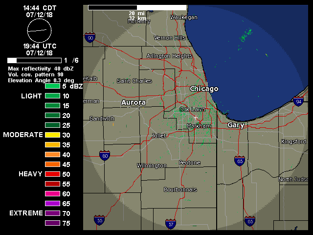
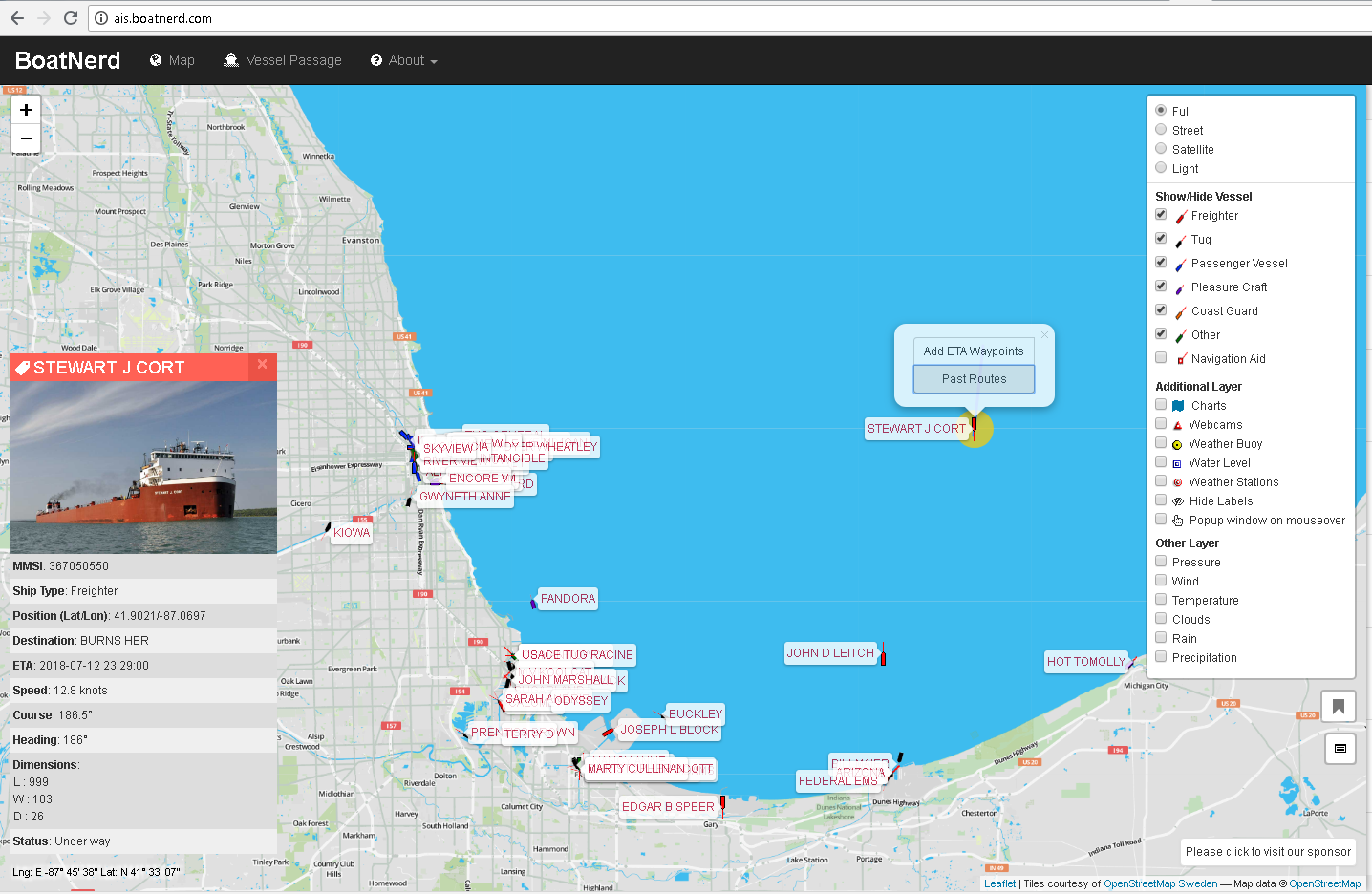
Freighter visible on weather radar
The Terminal Doppler Weather Radar system for Midway Airport caught the freighter Stewart J. Cort traveling on Lake Michigan towards Burns Harbor, IN. It's the return out in the middle of the lake heading south. I ID'd the ship with AIS Boatnerd
Monday, May 02, 2016
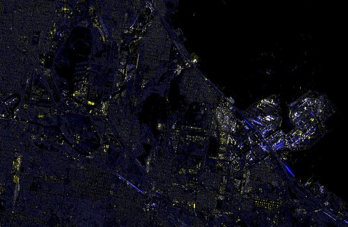
SAR image of the Calumet region of Chicago
I've been working on manipulating the large images offered by the Sentinel satellite. I found an image of the city of Chicago region on April 10th, 2016, and have been taking a look at it. The data image is 25000x16000. I grabbed the HH(the Horizontal transmitted, horizontal received polarization) and HV images (horizontally transmitted, returned vertical polarization), normalized them and made them R and B in an RGB set. The G I created by adding the two images together. Adjusting the hue allows for greater visual impact of the image.
This is the Calumet region of southeast Chicago and Northwest Indiana, a heavily industrialized region. Lake Calumet, Lake Michigan, Wolf Lake, and the Calumet River/Cal Sag all show with no reflectivity at this normalization (you'll recall the previous post where Lake Geneva had some return from waves). The ArcelorMittal steelworks sits out on the right as a highly reflective region of pipes, stacks, rail cars and other industrialness, with the BP Whiting refinery to the left of it as another nearly continuous return. Long linear blue streaks are presumed oil or ethanol conveys consisting of mile-long packs of tanker cars that are bright in the HV channel. Shipping containers, barges, oil tanks and rail cars that are not tankers all reflect highly in the HH return. Even Binions Horseshoe floating casino shows up brightly. A bright return in the upper left I assume is the tower at Promet steel.
Friday, June 03, 2011
Natural background radiation in Chicago
A recent inquiry brings up the question of what's the normal natural background radiation rate in Chicago? Using the EPA's online tool, we see the budget for naturally occurring sources listed as
(all numbers per year)
26 mrem for cosmic radiation
2 mrem for elevations up to 1000ft
46 mrem from terrestrial K, U, Th in soil (aka not Colorado Plateau or Gulf and Atlantic Coasts but normal US soil)
0 mrem from radon&daughter products (I'm excluding it here from this calculation but it's a sizeable percentage of your yearly dose)
74 mrem total, which comes out to about 8.4 urem/hr or microrems per hour. The long-term average in my basement office runs at about 7.6uR/hr.
From Duval, J.S., Aerial gamma-ray surveys of the conterminous United States and Alaska, you can see here that the approximate average exposure rate from naturally occurring U, K, and Th in the ground is about 4.5uR/hr at 1m above the ground for Chicago. I say about because the survey didn't look at heavily urbanized ground. But with the high resolution data and a geologic map you should be able to predict what it should be.

The Straight Dope unfortunately printed an error about it in 1980, claiming the rate in Chicago was 2 millirems per hour. That's really off; it's 1/250 of that.
Wednesday, March 16, 2011
Geiger Counter back up
My long-suffering Geiger counter is now back up and running.
http://www.lib.uchicago.edu/~dean/float.htm.
Now, as has been pointed out, this particular instance of this experiment is really an experiment, and is run only by me, for only experimental purposes. It doesn't represent any opinion or endorsement or opinion of any entity, whether the University of Chicago Library or the University or anything else. It is not a service. It represents nothing, is not calibrated, and should not be relied upon by anyone for anything. Don't email or call anyone but myself about it.
This instance is located in my office on the A-level of the Regenstein Library, the first basement level of a six-story building. The levels average about 8 microrads/hr here. Outside at Ryerson Physical Laboratory on the fifth floor, levels average to about 12 microrads/hr, which indicate the shielding provided by the Regenstein against the cosmic ray flux.
The problem I've been having with this counter was with the associated AW-SRAD software, which runs under DOS, doesn't appear to support virtual COM ports above COM4. On my Windows XP PC I had installed an Arduino which offered a similar USB Serial converter and I theorize at some point there was a conflict and the Geiger counter with its FTDI USB to serial converter took a high COM port at COM5. After removing the Arduino, I then disabled the real serial port at COM1 and forced via Device Manager->Ports->USB Serial Ports the port to go to COM1.
Tuesday, March 01, 2011
Evening passes for the ISS (International Space Station) and the Shuttle in Chicago
A number of visible passes for Chicago this week:
http://www.heavens-above.com/PassSummary.aspx?satid=25544&lat=41.781312&lng=-87.605097&loc=Chicago&alt=0&tz=CST
http://www.heavens-above.com/PassSummary.aspx?satid=25544&lat=41.781312&lng=-87.605097&loc=Chicago&alt=0&tz=CST
Tuesday, September 07, 2010
Today's sunny and windy weather
Click to enlarge to medium size. The link below goes to the really big image.
Today's weather in Chicago as seen from above via the MODIS imager on the Terra satellite. It was sunny and very windy with winds out of the southwest. It looks like you can see some dust streamers coming out off the lakeshore. Click on the link below for the huge 5200x6000 image with 250m resolution.
http://ge.ssec.wisc.edu/modis-today/index.php?satellite=t1&product=true_color&date=2010_09_07_250&overlay_sector=false&overlay_state=false&overlay_coastline=true§or=USA3&resolution=250m
Credits: http://ge.ssec.wisc.edu/modis-today/credits.html
Wednesday, August 04, 2010
Haze and smoke from western Canada
Haze and smoke visible in on the visible satellite image for this afternoon might give the less humid weather the next few days in Chicago a tinge of non-clarity.
http://www.osdpd.noaa.gov/ml/land/hms.html
http://www.osdpd.noaa.gov/ml/land/hms.html
Thursday, April 29, 2010
Thursday, March 04, 2010
Evening ISS passes for the next few days in Chicago
http://www.heavens-above.com/PassSummary.aspx?satid=25544&lat=41.781312&lng=-87.605097&loc=Chicago&alt=0&tz=CST
4 Mar -2.4 19:27:17 10 WSW 19:30:00 44 NW 19:30:00 44 NW
5 Mar -3.3 18:17:05 10 SW 18:19:55 60 SE 18:22:47 10 ENE
6 Mar -2.2 18:42:14 10 WSW 18:45:00 41 NNW 18:47:31 12 NE
7 Mar -1.0 19:08:01 10 WNW 19:10:16 20 NNW 19:11:50 14 NNE
8 Mar -2.1 17:57:05 10 W 17:59:50 39 NNW 18:02:35 10 NE
It might actually be clear!
Saturday, September 05, 2009
Early September ISS Shuttle passes in Chicago
See the International Space Shuttle and the Shuttle together in orbit here in Chicago:
http://www.heavens-above.com/PassSummary.aspx?satid=25544&lat=41.781312&lng=-87.605097&loc=Chicago&alt=0&tz=CST
http://www.heavens-above.com/PassSummary.aspx?satid=25544&lat=41.781312&lng=-87.605097&loc=Chicago&alt=0&tz=CST
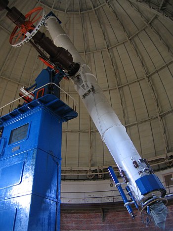
Thursday, April 09, 2009
400 Years of the Telescope: Friday on PBS
This such an auspicious year. I watched an interview on Chicago Tonight with one of the creators of "400 Years of the Telescope", to be broadcast on PBS this Friday. Immediately a shot of the Yerkes 40-inch refractor passed by in glorious HD, a scope I am intimately familiar with, and now I am compelled to watch. Friday at 8PM on WTTW. Of course, I am very happy when E.E. Barnard pops up on the schedule page on the site--Barnard's experimentation with astrophotography has a tie to the RAS observatory: our 1895 Warner and Swasey mount was first lent to Yerkes Observatory so Barnard could test camera lenses.

Thursday, January 22, 2009
Chicago FM radio band scan
Here's a band scan of all FM radio stations heard Wednesday night in Chicago with a Degen 1103. I attached it to two random length wire dipoles, oriented north/south and east/west and could switch between the two.
I used V-Soft's signal strength database to ID the strongest stations. This helps when not all stations are in Chicago.
For medium and low strength stations, I used the FCC database for various queries:
for all stations within 100km of me, for instance, click here.
You can get radio coverage maps from the FCC, or more refined maps from Radio Locator that show how likely it is to pick up the station.
Antenna is the orientation of the dipole; so the note "east/west" means the wire is strung east/west and sensitive to signals coming from the north or south.
Station IDs were either heard, inferred from strength, music type, from the list of Chicago stations, or best guess from distant station lists.
Since formatting is horrible, here is the Excel spreadsheet.
If a frequency is not listed, it was a channel subject to bad interference from a neighboring station.
The idea of finding the clear channels is to find one suitable for meteor scatter work: a normally too-distant station (because it is over the horizon) can suddenly boom in because the signal is reflected from a ionized meteor trail halfway between the listener and broadcaster.
Some interesting results: WXXC and WBYR, located in Marion and Fort Wayne, IN, at 150 miles away.
I used V-Soft's signal strength database to ID the strongest stations. This helps when not all stations are in Chicago.
For medium and low strength stations, I used the FCC database for various queries:
for all stations within 100km of me, for instance, click here.
You can get radio coverage maps from the FCC, or more refined maps from Radio Locator that show how likely it is to pick up the station.
Antenna is the orientation of the dipole; so the note "east/west" means the wire is strung east/west and sensitive to signals coming from the north or south.
Station IDs were either heard, inferred from strength, music type, from the list of Chicago stations, or best guess from distant station lists.
Frequency Call sign Strength Antenna notes
87.7 WLFM-LP   spanish news (tv carrier)
88.1 WCRX  east/west dance mono
88.1 WSSD  north/south R&B / announcer talking over song
88.5 WHPK-FM strong  "very local, college"
88.9 WIIT weak east/west college
89.3 WKKC   smooth music
89.5    hip-hop
89.7 WONU   Christian
90.1 WMBI-FM strong  Christian
90.5 WRTW?   rap
90.7 WAUS weak  classical
90.9 WDCB  north/south
91.1 WGSI weak  focus on the family / fox news / faint music
91.5 WBEZ strong
91.9 WJCH   piano music
92.3 WPWX   rap
92.5  clear (trace)
92.7 WCPT
93.1 WXRT-FM
93.3  clear (trace) north/south
93.5 WVIX   spanish
93.9 WLIT-FM   talk
93.7 WTRX-FM or WBCT  north/south country
94.1  clear (trace)
94.3 WJKL   christian
94.7 WLS-FM   rock
94.9  clear (trace)
95.1 WIIL
95.5 WNUA   jazz
95.7  clear (trace)
95.9 WEFM or WERV-FM  east/west jazz
96.3 WBBM-FM   rock?
96.5  clear
96.7 WSSR
97.1 WDRV
97.3 WQBW? faint  "Milwaukee, WI 104mi"
97.5 WHMS   lite
97.9 WLUP-FM   MISSING?
98.1 WIBN or WZOE  north/south "seeger, classic hits radio online"
98.3  strong  local CPU
98.7 WFMT   classical
98.9 WBYR   "fort wayne, IN ""The Bear"" 153mi range"
99.1 WXTT  east/west "Extra rock Danville, IL 114mi"
99.5 WUSN   country
99.9 WCPQ strong
100.3 WILV   70's
100.5  clear (trace)
100.7 W264BF  east/west Christian
101.1 WKQX   alt
101.3  clear
101.5 WBCH? WBNQ? WNSN?   modern WBCH? WBNQ? WNSN?
101.9 WTMX   R&B
102.1  clear (trace)
102.3 WYCA  east/west gospel
102.7 WVAZ   love or Christian
102.9  clear (trace)
103.1 WVIV-FM   spanish
103.5 WKSC-FM   modern/dance
103.7  clear (trace)
103.9 WXRD  east/west rock (political)
104.3 WJMK   rock
104.5  clear (trace)
104.7 WCFL  east/west christian
105.1 WOJO   spanish
105.5 WJLE   country
105.9 WCFS-FM   country
106.3 WSRB   hip-hop
106.7 WPPN   spanish
106.9 WXXC   Marion, Indiana!
107.1 WZVN   rock
107.5 WGCI-FM   hip-hop
107.9 WLEY-FM   spanish
Since formatting is horrible, here is the Excel spreadsheet.
If a frequency is not listed, it was a channel subject to bad interference from a neighboring station.
The idea of finding the clear channels is to find one suitable for meteor scatter work: a normally too-distant station (because it is over the horizon) can suddenly boom in because the signal is reflected from a ionized meteor trail halfway between the listener and broadcaster.
Some interesting results: WXXC and WBYR, located in Marion and Fort Wayne, IN, at 150 miles away.
Friday, December 26, 2008
Truth and media reports: Chicago fog
Kristyn Hartman wasn't trying too hard on her "live" report for the 10 o'clock news report for WBBM Channel 2 in Chicago, about the fog stopping all flights at Midway. As she reported live from the top level of Midway, you could see the parking garage off in the distance--indicating the bad fog had lifted, even while she says "As you can see, because of the thick fog...". At the worst of the fog, it was in fact a few hundred feet visibility, as they had been reporting, as they were interviewing and getting the stock shots. But they should have admitted the fog had lifted at the time of the live report, as the parking garage is over 3000 feet from the location of the live report. Sloppy reporting. Even just a few minutes after the live report, Ed Curran the meteorologist was reporting visibility was a full mile at Midway.
P.S. This isn't to disparage the seriousness of the fog this evening. It was very dense this evening. But it wasn't dense at the moment of the live report, and that's all I'm trying to write.
P.S. This isn't to disparage the seriousness of the fog this evening. It was very dense this evening. But it wasn't dense at the moment of the live report, and that's all I'm trying to write.
Thursday, November 20, 2008
See the International Space Station and Space Shuttle in Chicago
The next several evenings offer great possibilities to view the ISS and Shuttle docked from Chicago. See this link for viewing times.
3/18/2009 UPDATE: Take a look for current Shuttle passes.
3/18/2009 UPDATE: Take a look for current Shuttle passes.
Friday, October 03, 2008
Article in Sun-Times about Light Pollution
Yes, Light pollution does affect the ecology of the region.
http://www.suntimes.com/lifestyles/1199598,CST-NWS-night03.article.
Do I believe "A spokeswoman for the Chicago Bureau of Electricity said the city "has been actively pursing different methods to address the issue of light pollution."? Not in a second.
The University of Chicago just added over $7000 in electrical costs a year in extra, non-effective lights on campus. Is that sustainable?
Sunday, September 14, 2008
Raft
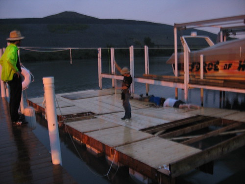
My time has been taken up with four friends of mine who are building a raft. Building a raft to travel from Chicago to New Orleans. I've been helping out as my schedule allows, although I took a few days off recently to help out on moving the preassembled parts from the backyard of a Hyde Park apartment to the Croissant Marina on the Little Calumet River. (This marina is a great spot--amazing for the friendliness, the methane purgers on the other side of the river, and the barges passing silently by). The weather gods have not been kind though. The majority of the water on the Little Calumet is effluent, and this weekend Chicago received the highest one-day precipitation event ever, AND the remnants of Hurricane Ike, in two separate rain events. In the scheme of things, it was so bad they opened all the normally closed locks that keep the Chicago river and canals from flowing into Lake Michigan. So, our previous spot at the marina is now covered in combined sewage and storm output by ten feet. It put a damper on the weekend for a lot of people; a lot of people are flooded out of their basements and apartments. Ryerson Observatory reports almost 11 inches of rain in the past seven days.
While we now have a 16ftx32ft raft, we still need to mount the 35hp motor and construct the cabins and hammock supports for the travelers. Try this link for construction photos. You might be able to see it without a facebook account--I'm just dumping stuff without much editing.
Friday, August 15, 2008
SDSS conference news
Sloan Digital Sky Survey summary conference this weekend.
Press release
The likely press highlight of the Solar System session on the morning of Monday, August 18 will be announcement of the discovery (by SDSS astronomer Andrew Becker) of a remarkable object that is currently about the same distance from Earth as the planet Uranus but whose 27,000-year orbit carries it to more than 70 times that distance. This object is akin to the famous dwarf planet Sedna, but its orbital properties are considerably more extreme, with a much more elongated path that takes it nearly twice as far from the Sun.
Press release
Thursday, August 14, 2008
When in doubt, blame the instrument: It wasn't the lightning.
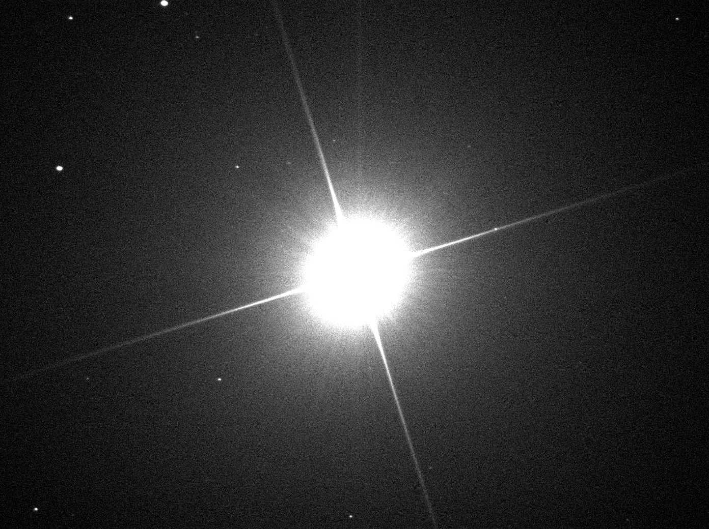
The WGN Weather blog shows a video from Bucktown of the intense thunderstorm of August 6th here: http://blogs.trb.com/news/weather/weblog/wgnweather/2008/08/incredible_viewer_video.html, but they claim that the nearby lightning strike at the end of the video actually produced arcing close to the camera. That wasn't the case. The "arcing" is actually an artifact of the CCD sensor in the video camera. To understand what's going on, you'll have to deal a little bit with the physics of CCDs. In silicon, incoming photons will excite electrons out of a lower energy state and into the "conduction" band where it can then migrate through the material. You can call this liberating the electron. In a CCD control voltages create zones where these freed electrons are trapped in the silicon until they are moved out and measured. Those zones are best known as pixels. Depending on the type of CCD, when the exposure is over, the electrons are moved pixel by pixel in columns to be read.
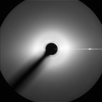
Intensely bright sources of light will produce so many electrons that they will overwhelm the control voltage and flood out of the pixel and into the surrounding pixels and circuitry, producing spurious effects. You've probably seen these effects -- it starts showing up at 1:57 in the Yeah Yeah Yeahs video for Maps for example, or in the SOHO image above (it's Venus doing the blooming).
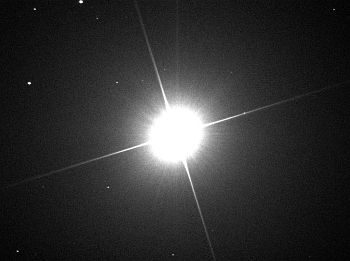
In this case the electrons flow out and down the columns that the electrons would normally be read. The Sun is a great source of column bleeding in a lot of videos online: see this one, for instance. Or bright stars--here is a weak version (it's the faint vertical column, not the diagonal streaks):
Since it's difficult to control all the sources of light in any possible photo scene, the CCD manufacturers have ways of trying to mitigate the overflowing electrons. One technique is to put drainage canals around the pixels and dump the electrons. This is good, but the extra space for drainage costs you some light sensitivity and light measuring accuracy.
Another problem can develop while you are moving the electrons off the CCD to be measured--if you have a shutterless camera, then light is still hitting all the pixels and can still cause overflow problems. One technique (used a lot for video cameras, at least in the old days) is to make the CCD twice as big with half of the chip covered up. At the end of the exposure you quickly move the electrons in the lit part over to the dark part and then leisurely read them out. This helps, but you can still have those overflowing electrons come down into your dark area.
So, in the lightning video, you can see that the extremely bright strike produces too many electrons in the CCD of the camera, and they flow 1. into the dark frame-transfer area and 2. down the columns (the vertical bleeds).
You can see at least one of these effects in some of the other strikes in the video.

Intensely bright sources of light will produce so many electrons that they will overwhelm the control voltage and flood out of the pixel and into the surrounding pixels and circuitry, producing spurious effects. You've probably seen these effects -- it starts showing up at 1:57 in the Yeah Yeah Yeahs video for Maps for example, or in the SOHO image above (it's Venus doing the blooming).
In this case the electrons flow out and down the columns that the electrons would normally be read. The Sun is a great source of column bleeding in a lot of videos online: see this one, for instance. Or bright stars--here is a weak version (it's the faint vertical column, not the diagonal streaks):
Since it's difficult to control all the sources of light in any possible photo scene, the CCD manufacturers have ways of trying to mitigate the overflowing electrons. One technique is to put drainage canals around the pixels and dump the electrons. This is good, but the extra space for drainage costs you some light sensitivity and light measuring accuracy.
Another problem can develop while you are moving the electrons off the CCD to be measured--if you have a shutterless camera, then light is still hitting all the pixels and can still cause overflow problems. One technique (used a lot for video cameras, at least in the old days) is to make the CCD twice as big with half of the chip covered up. At the end of the exposure you quickly move the electrons in the lit part over to the dark part and then leisurely read them out. This helps, but you can still have those overflowing electrons come down into your dark area.
So, in the lightning video, you can see that the extremely bright strike produces too many electrons in the CCD of the camera, and they flow 1. into the dark frame-transfer area and 2. down the columns (the vertical bleeds).
You can see at least one of these effects in some of the other strikes in the video.
Tuesday, August 05, 2008
In case of weather emergency in Chicago
Rely on WFLD, Fox 32, for your severe weather information. Do not expect the otherwise stellar Tom Skilling at WGN to give you info until well after the threat passed you by. This is born out by the south suburban tornado in June and yesterday's severe weather, which I watched out the window while downtown during round 1 and in Hyde Park during round 2. Telling the bartender to switch to WGN offered no new information other than the county was under a tornado threat--and that was obvious from watching the Cubs game. Watch the line organize here.
Subscribe to:
Posts (Atom)