
Wednesday, May 04, 2016
Revisiting the Lake Geneva SAR image
I realized my first processing of the Sentinel 1A radar image of Walworth County, WI, was deficient and I lost a lot of the details, so here's a much better grab of the HH channel.

Monday, May 02, 2016
SAR image of the Calumet region of Chicago
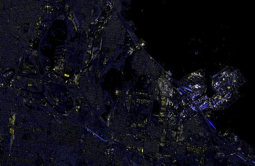
I've been working on manipulating the large images offered by the Sentinel satellite. I found an image of the city of Chicago region on April 10th, 2016, and have been taking a look at it. The data image is 25000x16000. I grabbed the HH(the Horizontal transmitted, horizontal received polarization) and HV images (horizontally transmitted, returned vertical polarization), normalized them and made them R and B in an RGB set. The G I created by adding the two images together. Adjusting the hue allows for greater visual impact of the image.
This is the Calumet region of southeast Chicago and Northwest Indiana, a heavily industrialized region. Lake Calumet, Lake Michigan, Wolf Lake, and the Calumet River/Cal Sag all show with no reflectivity at this normalization (you'll recall the previous post where Lake Geneva had some return from waves). The ArcelorMittal steelworks sits out on the right as a highly reflective region of pipes, stacks, rail cars and other industrialness, with the BP Whiting refinery to the left of it as another nearly continuous return. Long linear blue streaks are presumed oil or ethanol conveys consisting of mile-long packs of tanker cars that are bright in the HV channel. Shipping containers, barges, oil tanks and rail cars that are not tankers all reflect highly in the HH return. Even Binions Horseshoe floating casino shows up brightly. A bright return in the upper left I assume is the tower at Promet steel.
Subscribe to:
Posts (Atom)