
Showing posts with label volcanism. Show all posts
Showing posts with label volcanism. Show all posts
Friday, May 21, 2010
Eyjafjallajökull eruption: webcam at midnight
It's midnight in Iceland and nearly midsummer with a volcano erupting, what do you do? Hang out in front of the thermal camera.

Wednesday, May 12, 2010
Eyjafjallajökull eruption: webcams
There are several webcams watching the Ejyafjallajökull eruption; and at this time of year the plume is illuminated all the short night long. I watched the sunset at 10:30PM and am now watching the sun rise at 4:30AM. The eruption continues through the Arctic summer night.
http://eldgos.mila.is/english/eyjafjallajokull-fra-hvolsvelli/
http://eldgos.mila.is/english/eyjafjallajokull-fra-thorolfsfelli/
This one is closer and has a thermal IR camera as well; but it's also more often obscured by ash and fog.
http://eldgos.mila.is/english/eyjafjallajokull-fra-hvolsvelli/
http://eldgos.mila.is/english/eyjafjallajokull-fra-thorolfsfelli/
This one is closer and has a thermal IR camera as well; but it's also more often obscured by ash and fog.
Friday, April 23, 2010
The view from Thorvaldseyri of the Eyjafjallajökull eruption
The view from Thorvaldseyri of Eyjafjallajökull

You can just pick out the ice sheet from underneath the clouds.
Compare this with the view the farmer had recently:
http://icelandreview.com/icelandreview/upload/images/news/almennt/thorvaldseyri_olafur_eggertsson.jpg
From:
http://icelandreview.com/icelandreview/daily_news/?cat_id=16539&ew_0_a_id=361234
Sunday, April 18, 2010
Eyjafjallajökull eruption: gorgeous video
The NY Times Lede blog has linked to BBC Channel 4 video of the eruption. From the look of it, the videographer had one of the many excursion drivers take them up Thórsmörk (or Þórsmörk) valley on the north side up high enough to look at the eruption without dealing with the jokulhaup (or glacial flood) in the river. If you have ADD you will miss the active sub-Plinian eruption and great lightning in latter half of the video.
UPDATE: the waterfall at the beginning is Seljalandsfoss. I have a photo of it here: http://www.flickr.com/photos/dwarmstr/4532063271/.

EDIT: calling it sub-Plinian.
UPDATE: the waterfall at the beginning is Seljalandsfoss. I have a photo of it here: http://www.flickr.com/photos/dwarmstr/4532063271/.
EDIT: calling it sub-Plinian.
Eyjafjallajökull eruption: planes vs. volcano
An interesting data point about the Eyjafjallajökull eruption: the disruption of the European aviation market reduces the CO2 output by an order of magnitude more than the CO2 released by the volcano itself,

Source: http://www.informationisbeautiful.net/2010/planes-or-volcano/
Source: http://www.informationisbeautiful.net/2010/planes-or-volcano/
Thursday, April 15, 2010
Eyjafjallajökull eruption
I was just reading about the Eyjafjallajökull eruption yesterday and the rather bold tourist enterprise sprung up to visit it, when I see it has erupted in an explosive manner. The new path to the surface for the magma opened under the ice sheet (jokull) instead of bare ground, and water/magma interactions produce copious amounts of gas. Gas is a bad thing when it comes to magma. It makes thing go boom. Instead of a lava fountain and a tourist stop in Iceland, now we have flooding as the glacier melts, and air travel restrictions as the volcano generates large plumes up into the atmosphere from the phreatic eruption. The Icelanders are concerned about the flooding and the fluorine from the ashfall. For the geology, the composition of the magma (how much silica is in it, how much gas is in it), its interaction with the surrounding rock, and how the magma changes in composition as time increases are the interesting things. For the British sitting waiting for the air to clear, realize that ash is just magma pulverized through explosive means. Blame the gas.
Here is some good information on the location and the inflation/deflation data.
Here is some good information on the location and the inflation/deflation data.
Monday, April 13, 2009
SO2 plume from Galapagos volcanic eruption
You can see the sulfur dioxide (SO2) plume from the Galapagos volcanic eruption via the OMI on the Aura satellite (which I'm using to watch for hopefully great sunsets here):

NOAA/NESDIS/NASA-Goddard -- Click to enlarge to global view
NOAA/NESDIS/NASA-Goddard -- Click to enlarge to global view
Friday, March 27, 2009
Redoubt volcano: image of the week
This is definitely the image of the week for the Redoubt eruption.

This is from a Japanese weather satellite staring at the Western Pacific, and the volcano is near the limb of the Earth from its perspective.
Picture Date: March 26, 2009 17:30:00
Image Creator: Dehn, Jonathan / NWS
This is from a Japanese weather satellite staring at the Western Pacific, and the volcano is near the limb of the Earth from its perspective.
Picture Date: March 26, 2009 17:30:00
Image Creator: Dehn, Jonathan / NWS
Thursday, March 26, 2009
Redoubt volcano ash plume and sunsets
You may recall some fantastic sunsets in Chicago this summer from some eruption in the Aleutians. Now, since Redoubt has erupted, I was curious if the plumes were heading this way. In July I was unable to find readable (i.e. a common image format) data from the ozone monitor on the Aura satellite (which can track SO2 emissions as well). But now I've found this stuff, and it looks like at least one plume is over the contiguous 48 states, and Chicago in particular:

So if it's clear for you, and there is a plume somewhere within a few hundred miles of you, hope for a great sunset or sunrise!
It appears based on the weather there will be no clear sunsets for a while in Chicago though.

So if it's clear for you, and there is a plume somewhere within a few hundred miles of you, hope for a great sunset or sunrise!
It appears based on the weather there will be no clear sunsets for a while in Chicago though.
Thursday, March 12, 2009
Ask a volcanologist about funding
Were you wondering about the Republican response to the State of the Union speech where Gov. Jindal derided the '$140 million for something called "volcano monitoring."'? Me too. I did a double-take, and I assume most others with geoscience backgrounds did too. Regardless of your political leanings, I would assume people would want to know if a volcano erupted (say while you were in a jet plane heading to Japan) or what the risk was if there were an eruption (if you lived in a possible lahar zone, like parts of Tacoma, for instance).
Take a gander at an interview with Rick Wunderman at DCist.
Take a gander at an interview with Rick Wunderman at DCist.
Friday, February 13, 2009
Giant's Causeway on Mars
Much like the original Giant's Causeway, the universality of basalt lava exists elsewhere in the inner solar system--including Mars. Here is a very reasonable interpretation of a basalt flow on Mars.
 .
.
I still need to scan my Iceland crazy basalt cooling images.
. I still need to scan my Iceland crazy basalt cooling images.
Tuesday, September 02, 2008
Volcanic sunsets part 2
Jennifer points out the local Chicago view from 8/31. Last night the colors were all there without any crepscular rays. Another image at WGN Weather. Spaceweather says the cloud is moving off from North America, but I still thought last night's was great.
Sunday, August 31, 2008
volcanic sunset
Me, earlier this week walking to the supermarket: "Boy, it's funny. The western sky has odd colors. They vaguely remind me of the Mount Pinatubo colors from so many years ago. But there hasn't been any eruption lately."
Me, just now, reading Space Weather: Facepalm. Aleutian volcanic eruption a couple of weeks ago.
Also see WGN weather blog for a number of identical "Boy, what a sunset" posts.
EDIT: And thinking about it made me remember catching some news on Highly Allochthonous about how three of the Aleutian volcanoes were erupting and whether the volcanism was related.
Thursday, July 24, 2008
Granite counters: the claim of radiation risk

The New York Times has a surprising article today about the radiation risks of granite counters.
Granite is an intrusive rock--slowly cooled from magma several kilometers below the surface, the rock grows large crystals from the hundred-thousand to million year cooling period. It is also chemically more "continental"; that is, more quartz, more "felsic" minerals, as opposed to the "mafic" minerals that contain much olivine and pyroxene, two minerals rich in iron and magnesium. True granite is a chemically specific intrusive, and much of what is called granite isn't, but a cousin of it. Roughly you can say to expect quartz, feldspar (of some type, there are several), and a sheet silicate like mica or biotite.
Despite the popular image of the Earth's crust riding on an ocean of molten magma, there is little liquid under our feet. While it's hot, there is enough pressure to keep things solid. Occasionally something will upset that balance and allow the rock to melt, whether by bringing hot material up to a lower pressure (like at the mid-ocean ridges) or by adding a special ingredient to make it melt (like water released by ocean sediments subducting under a continent). Melting is complicated and rarely complete, and some minerals melt at a lower temperature than others, leaving behind and chemically changing what sort of rock it is. Granite is like this. It melts at a lower temperature than basaltic materials. It often contains more water. And it brings with it certain compatible elements including uranium and thorium. This is why granites are more radioactive than most rocks. They can contain 10-20x more uranium and thorium than the solid left behind. Some of the more exotic "granites" are pegmatites--the extremely large crystal remnants of the last little bits of liquid at the end of solidification--and they contain the highest amounts of these elements.
But is this a hazard? Granites I've encountered have rates ranging from nothing to about 10x background. This isn't that much. Time spent at cruising altitude is about 40x background at 500ft. It certainly wouldn't be worth the fuss of ripping up a kitchen, unless it was proven to be the source of elevated radon levels. After reading the literature about naturally occurring radon sources, I have difficulty assigning the radon to just a small granite piece. Any soil or rock within 4 gas-diffusion-days of the basement or slab can be a source of radon for a home, and the total amount of uranium in that quantity is going to exceed the amount in the countertop (especially the part of the countertop that is within radon's half-life time of the surface). If you covered your walls in granite it might be different.
Friday, July 27, 2007
Mt. St. Helens webcam
A wonderful service from the National Forest Service is a webcam showing Mt. St. Helens from Johnson Ridge Observatory--and now it's gone to a much higher resolution. It'll be interesting to see what sort of near-infrared performance the new NetCam XL camera has. The old camera would occasionally pick up the invisible glow of the hot dome at night.
Watch the slow growth of the reemergent lava dome in this movie from last year. (Others here).
Watch the slow growth of the reemergent lava dome in this movie from last year. (Others here).
Wednesday, May 30, 2007
Martian caves
There are Martian Caves--large skylights into a world we nothing of.
The Planetary Society's Blog has the article.
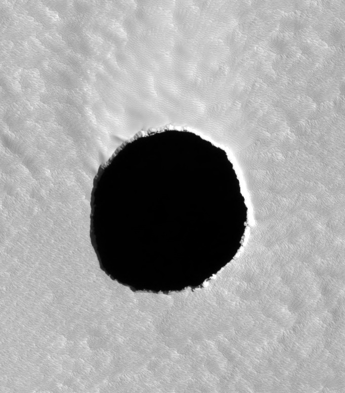
The Mars Reconaissance Orbiter's HiRISE imager and the Mars Odyssey's THEMIS IR imager worked together to confirm these are caves--dark during the day, cooler than sunlit surfaces during the afternoon (but still warmer than surface shadows), warmer at night. These are huge skylights--over 300ft in size, and they overhang, meaning the cave is bigger than the skylight. The caves found are all big, partially because the THEMIS imager has a resolution limit of 100m, so they couldn't use it to refine candidate holes found in the visible HiRISE data. The diameters of the caves were from 100 to 252 meters.
One of the caves, on the northeast flank of Arsia Mons:

They were all found on the slopes of Arsia Mons, the southernmost Tharsis volcano. A global view here; it's the circular blob in 5 o'clock position from the center. These caves are likely the result of lava tubes, formed when lava cools on the surface and emptying out below.
On one of the seven skylights, they saw the floor lit; this allowed them to calculate the depth of the cave at 130 meters. The lit cave is shown below.

As Cushing, Titus, Wynne, and Christensen wrote in their conference paper, these caves offer sanctuary from all sorts of radiation, both UV and cosmic rays, that exist on the surface of Mars and would be the primary limiter of life at Mars. The caves' existence is enough to spring to life the imagines of the unseeable world inside of them; we will likely never know the wonders of what they contain in our lifetimes. It is unfortunate that they are currently only known on the slope of a Tharsis volcano--high in the thin Martian atmosphere, we are limited in our ability to land a spacecraft there easily.
Images courtesy NASA/JPL/University of Arizona
The Planetary Society's Blog has the article.
The Mars Reconaissance Orbiter's HiRISE imager and the Mars Odyssey's THEMIS IR imager worked together to confirm these are caves--dark during the day, cooler than sunlit surfaces during the afternoon (but still warmer than surface shadows), warmer at night. These are huge skylights--over 300ft in size, and they overhang, meaning the cave is bigger than the skylight. The caves found are all big, partially because the THEMIS imager has a resolution limit of 100m, so they couldn't use it to refine candidate holes found in the visible HiRISE data. The diameters of the caves were from 100 to 252 meters.
One of the caves, on the northeast flank of Arsia Mons:
They were all found on the slopes of Arsia Mons, the southernmost Tharsis volcano. A global view here; it's the circular blob in 5 o'clock position from the center. These caves are likely the result of lava tubes, formed when lava cools on the surface and emptying out below.
On one of the seven skylights, they saw the floor lit; this allowed them to calculate the depth of the cave at 130 meters. The lit cave is shown below.
As Cushing, Titus, Wynne, and Christensen wrote in their conference paper, these caves offer sanctuary from all sorts of radiation, both UV and cosmic rays, that exist on the surface of Mars and would be the primary limiter of life at Mars. The caves' existence is enough to spring to life the imagines of the unseeable world inside of them; we will likely never know the wonders of what they contain in our lifetimes. It is unfortunate that they are currently only known on the slope of a Tharsis volcano--high in the thin Martian atmosphere, we are limited in our ability to land a spacecraft there easily.
Images courtesy NASA/JPL/University of Arizona
Tuesday, May 15, 2007
Tvashtar erupting
Wow--New Horizons has created an animation of Tvashtar on Io erupting--it's gorgeous:

Credit: NASA/Johns Hopkins University Applied Physics Laboratory/Southwest Research Institute
Seen on The Planetary Society Blog.
See the description here.
Credit: NASA/Johns Hopkins University Applied Physics Laboratory/Southwest Research Institute
Seen on The Planetary Society Blog.
See the description here.
Monday, November 07, 2005
Nova: Volcano under the City
An episode of Nova I watched because it was 1. in HD and 2. Geoscience related. As unfortunately usual, another earth science Nova with excessive overdramatization. Like an earlier episode about the scablands of eastern Washington, the dramatics overwhelm any science presented. The research wasn't really explained until near the end, when they finally mentioned WHY volcanologists were going after fresh lava. Let's balance the danger/people/adventure aspect with more science. That's what Nova was for, wasn't it? Scientific American Frontiers does a much better job explaining science and what scientists do. Nova always had a bit of the National Geographic travelogue in it, but it's gone way too much to that now.
"Constant observation is necessary, for when it erupts, a new name could be added to the most deadly disasters in human history....Nyiragongo!"
"Constant observation is necessary, for when it erupts, a new name could be added to the most deadly disasters in human history....Nyiragongo!"
Subscribe to:
Posts (Atom)